Friday, April 29, 2016

The Second Day in Yosemite

We had two choices today.  We could drive 3.5 hours to Kings Canyon and Sequoia National Parks, or we could return to Yosemite.  And as badly as we wanted to see the other two parks, we decided to return to Yosemite for a more leisurely day.  We knew tomorrow might be a big day on the road, and a lower-paced day suited us better.

Since the sky was blue, we returned to Yosemite Falls to take better pictures of them, and then we went to the Wawona Valley.  There is a tunnel on that road, and right before the tunnel is an overlook.  We took this picture from there.


Nice, huh?  That is Bridalveil falls on the right, Half Dome toward the back, and El Capitan on the left.

The road to Wawona is as twisty as any we had driven, so the 35 miles took us about an hour.  We had planned to eat at the lodge there . . . older than Ahwahnee but not as grand . . . but the dining room had closed about fifteen minutes before we arrived.  So instead we went into a little store, bought some items and had a picnic lunch next to a beautiful, clear river.


We explored the pioneer village for a few minutes, taking pictures at the lovely covered bridge, and headed back down to Yosemite Valley. Wawona has a golf course, adirondack chairs are set up on the lawn, a tennis court is down the hill.  It is a sleepier part of Yosemite . . . 

We noticed that the rain was coming in, and when we arrived at Tunnel View we had to retake the above picture.  I thought it was beautiful in a different way!


We decided to then go to Tuolumne where we would see a small sequoia grove.  The bigger grove, Mariposa, which is in Wawona, is undergoing restoration, so this one would have to do.  The road to Tuolumne was equally twisting, and the elevation change even higher.  When we arrived, we got out of the car to rain and sleet.  But we decided that once we were there, we should go ahead and make the two-mile walk . . . with the dogs.


The way to the grove is entirely downhill (which meant we had to come back uphill).  The further down the hill we went, the foggier it got.  Don felt the fog made the walk more authentic.  When we saw the first sequoia tree, there was no mistaking it.  Some of the Ponderosa Pines were as tall as the Sequoias, but the girth of the Sequoias was two to three times the girth of the Ponderosas.  We learned that once Sequoia trees get taller than the surrounding trees, they do not grow much taller, in contrast with Redwoods that continue to grow.  We took pictures of one of the trees that had been cut out (many years ago) so people could walk through it.


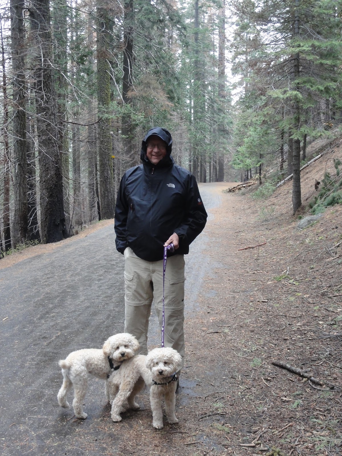
The mile walk back up was not so bad, but Jordy and Nelson wanted to play.  The tumbled and rolled as we walked up the paved but still dirty path, so that when they got in the car, they looked like this:


What muddy messes!  We were glad we took the walk, however, because although there were only 25 sequoias in this area, they were quite impressive.

Thursday, April 28, 2016

Yosemite Falls

As we made our way out of Yosemite Valley, we came upon the Yosemite Falls.  Because it is spring, all of the falls are running full bore.  We did not realize that the Yosemite Falls are one of the ten longest waterfalls in the world.  Seeing them makes us wonder what Angel Falls must really be like!

The Park Service has made a beautiful walking area for those who want to get closer to the Lower Falls.  We took the walk, but what we really wanted was a picture of the Upper and Lower Falls.  Luckily, that was not too hard to get.  Unfortunately, on Tuesday, it had gotten cloudy.  Wednesday morning, however, the sky behind the falls was blue, and we returned to take a better picture.  Glad we did!


This was taken from the Yosemite Valley Visitor Center.  I liked how it showed so much water!


The Ahwahnee Lodge

The Awahnee Lodge in Yosemite is another of the beautiful big lodges, similar to El Tovar in the Grand Canyon, Furnace Creek in Death Valley, or the Yellowstone Lodge.  This spectacular lodge's dining room is as grand as any we have seen.  The ceiling in the dining room was thirty feet high, with huge beams held together by steel lashing shaped like arrowheads.  Indian motifs were painted around the edges othe ceiling, the floors were painted with similar motifs, and the chandeliers were huge.


We were fortunate to sit in the back near a window that allowed the wonderfully fresh air to billow in.  We had views of California dogwoods and other California plants, all while enjoying a nice lunch.

This was not the view, but the pink dogwoods were just down the road.

What I don't understand is why the name has changed to the Majestic Yosemite Lodge  Yes, it is Majestic, but it has been the Awahnee Lodge forever.  For some reason, when the vendor for the park changed to Aramark, the name changed.  One of the waiters said something about intellectual property and money - it didn't make sense to me.  How does one change the name of something so historic?

Anyway, it was a beautiful place to eat and we enjoyed ourselves immensely.

Wednesday, April 27, 2016

El Capitan

Not much farther up the valley, we came to a huge granite cliff.  At first, I didn't think it could be El Capitan because the map made it look as if El Capitan was much farther away.  I was wrong.  What a beautiful, imposing geological marvel it is.  We did not see anyone climbing it (though we did see climbers on another rock near the Ahwahnee Lodge (now renamed the Majestic Yosemite Lodge.  How does one rename a piece of history?  But I digress.), but we did have beautiful blue skies that allowed us beautiful pictures.  At one place, we went down to a beach, and because not as many people frequent the park in April, we were able to get a "peopleless" picture!  Here is the same picture using two different cameras.  Amazingly, the bottom one is the iPad, which gave a better color quality to the picture!


I felt much about El Capitan the way I did about the Grand Canyon.  No picture can do it justice!

Bridalveil Falls

We have seen several Bridalveil Falls - one in Oregon, for example.  The one in Yosemite is much different from the one in Oregon, and I thought the one in Oregon was more accurately named.  But nevermind the small stuff.  This is one awesome waterfall.

It is running full bore because of the spring runoff, and if one gets too close, one gets wet!  We stayed back a little because we didn't want to get our cameras wet.  What we thought interesting about this particular fall is that by summer's end, it is just a trickle.  Hard to believe it could dry up that much.


The above picture is taken from a ways away.


We really liked the way the sun is shining on the falls, and the mist is "ghosting" up around the trees.

Yosemite

The two of us had never been to Yosemite, so we decided we should go while we were in California.  We stayed in a KOA park about 40 miles from the entrance to the park, and after taking a leisurely morning, we drove to Yosemite.

The road is a twisty winding thing, rather narrow but beautiful.  A river, the Merced, runs next to the road, and since it is April, it is running rather swiftly.  Beautiful rapids, lots of rocks, and waterfalls from the side of the road made for a very scenic drive.

We came upon a detour, and at first we couldn't figure out how there could be a detour in a one-road canyon.  Then we saw a large rock slide, called the Ferguson Slide.  It first came down in 2006, and the road was closedfor several months.  They built a temporary road with bridges, but the bridges would not support larger rigs.  Eventually they constructed two temporary bridges that could handle buses and RVs, and, using the old road, made a detour that is a one-lane only road, controlled by stop lights.  It works, but I imagine in the summer and even on weekends, it gets pretty slow!


The drive just to arrive at Yosemite is about an hour.  We spent about seven hours there, which will be documented in several posts.


The Brilliance of the National Park System

I had not thought much about it before this trip of many National Park visits.  I had always just accepted that the National Parks were a good idea.  But the last few visits have convinced me of the brilliance of the idea.

John Muir was quite the visionary.  He recognized that Yosemite was a special place, and his conversations with President Roosevelt must have been convincing.  And thank goodness they were.  I cannot imagine what Yosemite would look like if it had not been protected; or Yellowstone or any of the other parks.  Has the Park Service done everything right?  Of course not.  But because of their oversight, sequoia trees and bristlecone pines still exist; everyone can experience the beauty of Yellowstone, Arches, and the Great Smoky Mountains; and areas of our country have been protected from decimation for all to enjoy.

I am proud of our nation for its National Park System. We need to support it so that future generations can experience the beauty we have experienced over the years.

Tuesday, April 26, 2016

Grateful

When we awakened in Torrey, we were greeted with snow . . . lots of it and still coming down.


We had read that there was a chain requirement over one of the passes so we decided to wait awhile before leaving.  By 10:00, the chain warning had been lifted, and we were on our way.

The first half of the trip was rather interesting.  It snowed the whole way, but thankfully it was warm enough that the snow was not sticking to the road.  Some of the passes were quite steep, the winding switchbacks without guardrails rather harrowing.


We called the picture above the Moki Dugway for RVs - it was challenging and one of the roads without guardrails.  

Once we were out of the snow, the drive became much easier.  The finals bits of Nevada were flat and straight, we managed to get through Sacramento after rush hour, which shortened the trip a bit, and finally got into Yosemite about 10:00.  A long, long twelve-hour day which gratefully went well!

Sunday, April 24, 2016

Great Basin National Park

We left Torrey, Utah, where we had stayed in a terrific RV park called Wonderland.  While Don filled the Willie, he sent me into a little bakery to pick up a cinnamon roll for him.  Little did I know they would have chai tea lattes available - hurray!  Win for both of us.

As we drove to Great Basin National Bank, we were on the Loneliest Highway in the U.S.  Now I would have to disagree with that, as we saw at least as many cars on that road as we do driving from Springer to Clayton.  But it was certainly straighter than the Clayton road!  At one point, we came across the Sevier Lake, which is not a lake at all but instead a dried salt bed.  It was pretty against the mountains, however.


When we drove into the Great Basin National Park Visitor Center, we thought we had hit a first.  There was not one car in the parking lot.  When I went to the door, however, I saw why . . . that particular center was closed, and we had to proceed to the visitor center at the Lehman caves.

The visitor center was small but very interesting.  We learned that the Great Basin is an area of Utah and Nevada where none of the rivers drain to the ocean.  We didn't know such a place even existed.  We also found that there were cave tours, and we decided to take one.

The caves were small but very interesting and fun.  The guide showed us many different shapes - stalactites, stalagmites, curtains (one that looked like bacon), shields, flows, and candles.  Shields are only present in about 80 caves throughout the US.  They are really cool looking, and I was excited that my pictures turned out fairly well.

This curtain resembles a piece of bacon

Two shields - unique round structures

One other interesting aspect of Great Basin involves a Winchester rifle.  We had read back in 2014 that a man had found a rifle while walking in the desert.  it was leaning against a tree and was obviously very old.  Turns out it is one of Buffalo Bill Cody's rifles, complete with a bullet that was lodged inside it.  The rifle is now on display because it was found in the Great Basin National Park.  Very cool!

I Cannot Do Anymore Red Rocks

After a week of looking at different kinds of red rocks we didn't think we could do another day of it, but there was one more Utah National Park, Capitol Reef, on our way to California, so we had to go.  The trip was only about 120 miles from Green River, but with the wind howling, it took us a little longer to arrive.  Don said he felt as if he had been arm wrestling the entire time.

The park itself is understated - no entrance booth at either end, and few side roads.  As we drove through the park to our RV park, we were able to see what sights we might want to include, which was very helpful.  After setting up the rigs and having lunch, we were on our way.

The first stop at the visitor center gave us a view of what we would see, and we took a short walk to see a small waterfall.  Small is too large a word to describe what we might consider a rapid!  But we needed the exercise.

The petroglyphs in the park were outstanding.  Many have been lost through erosion, but there are many more still.  The Fremont people were most prolific with their art, and we particularly liked the bear and the rams.  The art is now protected from graffiti, but it is still out in the weather where it can gradually be worn down.


We then took a scenic drive past Fruita, a Mormon settlement from the 1880's, and into the hills.  And although the rocks were red, there was a differrent geology about them.  The fascinating shapes and shadows would have been prettier with a little less wind and a little more sunlight, but my iPad still captured their beauty.


This particular picture is notable because of the grayish patch of Chinle sandstone at the top.  It is completely out of place geologically (although we would not have known had we not read about it), and because of that, the erosion has created some interesting hoodoos on top.  

On our way out, we stopped at Panorama point, hoping again for some good sunshine on the walls.  Unfortunately, many clouds drifted in, obscuring the sun. I got some decent pictures, but not what I was hoping they would be.  


We skipped a few of the hikes we normally would have taken, both because it was late and we were tired of the wind, but that was ok because we actually ate at a normal time, and I still had time to bake cookies.

Tomorrow Katie, Bart and Jerri leave for home, and Don and I head for Ely, Nevada, where we will go to Great Basin National Park.  We have no idea what is there, but we certainly hope there are not more red rocks.

Friday, April 22, 2016

Slot Canyons

Jerri had read about hiking into a slot canyon near Goblin State Park, and when the ranger told us we were close to it, we decided to finish the afternoon doing that.  We had to walk 1/2 mile before we entered the area where the slot canyon was, but once we got to the canyon, we knew it was going to be a nice walk.  Have a look:


This part twisted and turned, and then narrowed so much I wasn't sure we could get through!

The canyon is called Wild Horse Canyon, but we cannot figure out how a horse would get very far.  If it didn't get stopped by the large boulders, it would get hung up on the sides.  Either way, it was a very fun walk!

Goblin Valley State Park

Don had heard of Goblin Valley State Park while reviewing trips on an RV site on the web, and he thought it sounded interesting.  By the time we were headed to it, I think we all wondered if we could do one more "red rock" adventure, but we went anyway.

This particular park is comprised of numerous eroded sandstone "sculptures" that could be construed as goblins.  It is a very unique sandstone that scrapes off when touched and turns into a muddy mess when wet, therefore it was easy to see how the valley changes rather quickly.


There are three valleys of goblins, but we decided we didn't need to see all three.  In the valley where we were, we found rocks that looked like dinosaurs, mushrooms, and monkeys.  Young children would love coming here and running around, as long as it isn't too hot!  We got a great day, though the 35 mph winds were a little much.  Better that, however, than 100 degree heat!

Sego Canyon Revisited

When we went to Alaska, we were so taken with the pictographs (painted on) and petroglyphs (chiseled) at Sego Canyon that we had to take Bart, Katie and Jerri there.  We were prepared, however, as we just took cars and not the Willie.  That way we didn't have to try to turn around like we did the last time we visited.

We are still enthralled by the pictures done between 2000 B.C. and 1300 A.D.  The archaeologists have theorized that the ones that look like aliens were the earliest, with the others coming later.  It is a fascinating study in previous civilizations, and of course, we will never know the answer to the questions we have about them.


Thursday, April 21, 2016

The Difference Light Makes

Our sister-in-law, Jerri, has become quite the photographer.  She is excellent at seeing a good picture, and she emphasizes the importance of proper lighting.  On Thursday morning, Bart, Don and I went to Dead Horse State Park to try to capture some pictures in the morning light.  Then we came back in the evening to do the same with evening light.  I have four pictures to compare.  The first two are looking east in the morning and in the evening.


This is not too bad, considering the sun is shining from the left of the picture.  But the following picture was taken at about 4:00, with the sun behind my back.


The next picture taken in the morning looking west has the sun at my back.


And Jerri took this one in the afternoon.


These four pictures really helped me to see how important lighting is when taking a picture.  No wonder many of my pics just don't look too great!

Canyonlands

After Deadhorse State Park, we met the princesses at the visitor center at Canyonlands.  We decided to drive to the very end of the road and work our way back.

The Grand Point Overlook is between the Green and Colorado Rivers.  We took a two-mile hike to the end of the viewpoint, and I proved even old women can climb rocks.  The hike was on the edge of a cliff overlooking the Colorado, but at the end both rivers are in view.  Unfortunately, the light was not great so the pictures do not do it justice.

Afterwards, we stopped at several overlooks.  We were going to take one more hike, but it was too hot and steep, so we passed it.

Canyonlands is a nice park, but there is not nearly as much to do unless one is into mountain biking or Jeeping.  The Jeep we tow is too old to take the side roads and we are not into biking, so the few hikes we took were the extent of it.  There is not as much to see here as there is at Arches, but the deep canyons are certainly impressive.


While the Princesses Sleep

While Katie and Jerri slept, Bart, Don and I arose early and headed for Deadhorse State Park to see more red rocks.  Bart was hoping to catch the morning light, and I decided I would come along for the ride.

Deadhorse State Park is about 40 minutes from Moab, just northeast of Canyonlands National Park.  Bart had seen pictures of the meanders made by both the Green and the Colorado rivers before they enter Canyonlands and he wanted to try to get a beautiful morning shot of the cliffs.  Fortunately, the pups were allowed to walk with me, so we all piled out of the RV, each going our separate ways.

The cliffs were quite steep . . . very steep, as a matter of fact . . . and the light was changing the looks of them by the minute.  The pups and I walked a 2 mile trail, but Bart decided to walk around to a point to try to get the whole river on the gooseneck, so he walked about 5 miles.  Unfortunately, he was not able to get the shot he wanted, but he did get his 10,000 steps, so it was a win!

I was able to get some pretty spectacular shots of the river below, accented by wonderful shadows.


Shot from the east rim, the sun muted some of the beautiful colors.


This is the west rim, shooting with the sun.  I love the dark shadows!

Then while Bart was still taking pictures, I decided to whip up some butterscotch cookies for the eating.  I nearly finished the batch by the time he returned.  Another win for sure!


Wednesday, April 20, 2016

Don as a Second Language

Don has always had trouble with the Spanish language.  He was really not introduced to until he met me, and by then, it was too late.  But he tries.  For years, he has called the Sangre de Cristo mountains the Sangria de Cristo.  Well, I guess they are both red, but the Blood of Christ Mountains certainly sounds different from the Sangria of Christ Mountains - I think Christ only drank wine.

Then he began to call vegetables that were cooked to taste El Dante, rather than Al Dente.  On this trip, Sipapu (pronounced See pa poo) has suddenly become Sipapu (Sigh pa poo), though he has heard us pronounce it numerous times.

Chinle, Arizona (Chin lee) has become Chenille - like the fuzzy blanket.  

Who knows what other new terms he will come up with . . . but he has kept us entertained!

Arches National Park

By the time everyone was ready to go, Don and I had taken the dogs for two walks, eaten breakfast, taken showers, made reservations at three campgrounds, Facetimed with Diana and Caleb,  and gotten supplies ready to go.  Meanwhile, the other RV was a little slower . . . but that is ok.  Maybe we need to chill a bit.

Anyway, we arrived at Arches National Park about 11:00, and once we got our bearings, we began our journey.  We stopped first to see the Three Gossips, the Sheep's Head, and the Tower of Babel.

The tower of Babel is a huge rock cliff that looks intricately carved, even though it has been shaped by wind and water.


The Sheep's Head really does look like a sheep . . . or the Sphinx.

My favorite part was the area where the North Window and South Window were.  The walk was very pleasant, and the windows were spectacular.


I think they look like a pair of glasses, frankly, but no one asked me

We then went to two different areas where there are spectacular arches.  This final one, the Landscape Arch, is the size of two football fields.  It won't be too many years (in geologic time) before this one collapses.


After our steak dinner, we came back to take pictures of the full moon over the mountains.  When we arrived, however, the balancing rock looked amazing with the full moon behind it.